2. •
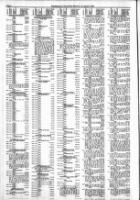
2.51
.77
2.
122.
7 2
7 2
1 7
7 7
7 7
7
,
o u
44 • 0
•• 5
4.7
512.21
427. 4
Lo I 1 0, 141
554.
2
2
2
5 .54
57. 2
DO
45.12
2'.11
4.2. 4
'.70
70 .91
.20
'25.47
2.71
1 2
2
2
2.5'
2 .17
1 2
7 Lo 0
1 2
710 0 4
2
1 2
17.57
24.
52.1
752
DV
2,70 . 3
7
741.65
2.4
1,521. 3
. 0
1
7
1
7
7
1
1 2
ZU
2
5 4.4
'52.89
n 30 T1S
154' th 134.5'
N 134.5' to POb
114.22
7
.15
,P Of' .....
15 Com 500' E of 5 pst
T6S AI7W 1" N 405' th 500'
t 111' th S 89 O� 33'
2624.16' to Wly RR R/W th S
5 .56' th W to pcb
1982 517.49
759 Com 44.7' of S Qtr pt Frt
22 T6S RI7W th E 23' 0
o 30' 431.1' to Hwy CIL
'lyon CIL to a pt of b
th S to pob
1982 11.96
760 Com 33.6' N of S qtr po
22 T6S RI1W th N lOS' E
208.1' S 105' th W 20 .7'
to pob
1 2 1,090.42
161 rom 1. 22 T6S Rl7W
run E 83 .1' th S 70 Deg 08'
511.7' th S 0 Oeg 05' W
217.62' to pob th S 66 0 ...
42' E 163.2' th SOD ... 05' W
128.22 ft th W 156.42' th
00 05' E 117.62' to pob
19 2 83.66
162 From N p 22 T6S Rl7W
run E 837.1' th S 70 Oeg 01' E
581.7' th S 66 0 42' E 520 ft
to pob th S 660 ... 42' E 229.9'
th S 49 0 11' W 222.5' th
66 0 ... 42' W 141.72' th N
23 0 ... 18' E 200' to pob
1982 50.94
763 Com 1118' E of W 41tr po of
sec 25 T6S RI1W th E 361'th
S 483' th 361' th N 413�
to
1982 134.15
7 4 T. 99' of the E 3 9' of NE
Qtr of S Qtr of qtr of Sec
21 T6S Rl7W
19.2 828.51
75Th. E Qtr SE Qtr Qtr seC
21 T6S R11W .xc th. E
491' th reof
1 12 525.66
766 Com 110' S of E Cor of SE
of Sec 21 T6S RI1W th
SIlO' th 300' th N 110' th
E 300' to pob
1982 75.47
767 Com 660.75' S of NE Cor of
SE of W 21 T6S R11W
th W 300' th N 0.15' th E 300'
th S 0.75' to pob
1 .2 179.39
768 Com 280' S of NE cor of S
Qtr of Qtr Me 27 T6S R 17W
t S 100' W 00' N 100'
00' to pob
1912 340.45
769 Com Cen Sec 27 T6S R l1W th
SliD 55' to Ely r/W CCC 1&
St Louis RR th S on r/W 100'
to of 5689.58' Rad Cur Lt
th SEly on Sd Cur a Ch 01 of
S 5 0 15' 43" E 496.8' th
1 0 38' 20" E 524' th N
129.19' th 0 55' E
201 .91' th 400' to pOb
1 82 1,031.10
770 Com 357.5' of Qtr po Me
27 T S RI1W th E 202.5' S
0' W 4' S 16" E 34' th S
241' th 55' th N 294.5' W
141.5' th 147.5' to pcb
1 .2 239.11
111 Com "7." S of NE cor of
Qtr of NE Qtr 27 T6S R 17W
t S 13.05' W 20'.7' N 313.05'
E to pob
1 2 476.54
772 Com 1095.4' S of E cor of
NW Qtr of Qtr sec 21 T6S
RI7W th S 240' W 1162.6'
N 28 ' E 148.1' N 59 .9' E
22.5' S 439.4' E 481. ' S
214' E 201.7' to pob
1 12 476.54
773 Com 70.1' SOD ... 20' W of
p 27 T6S RI7W th S 0
o 20' W 201' th S 19 Oeg
27' 208.7' th N 0 Oeg 20' E
201' th 19 0 27' W 298.7'
to pob
1 2 7 6. 5
774 Com 560' E 1& 30' S of N qtr
t' S 27 T6S RI7W th E 32'
th S 165' th 66' th N 165' th
E 4' to pOb
19 2 312.85
775 Com 661.65' W of E cor
27 T6S R 17W th 283.65' th
S 1 23.5' th 9 0 ... 50' IS"
E 282.2' NO� 03' 4 "
1322.7' to pob
1982 190.07
776 Com 604' E of Cor of S
Qtr of E Qtr S 2 T6S RI7W
th S 250' th E 268.6.' N 250'
to pob e thft W 64' th r of
1982 2 .47
777 Com 23 6.45' of SW cor
2 T S RI7W th 1585.64' th
S 15 d 11' 10" E 45.9' th N
5 0 15' 40" E 145.25' th
SOD 10' 10" W 332.55' th S
19 0 ... 24' E 116.6' th S 1301'
to S In 21 th W 292' to pob
Iso It th land lying Nly of
boy by .xt th E 1& W ere
pins ong th Ir r ectlve
bIng to at s ed of Long
La.
19 2 132.7'
771 Com at S Qtr Po of Sec 29 T6S
RI1W th 175' th W to cit of
th S 15 0 2.' E on cit to
S Lin of Sec 29 th E 201.1'
to
1 2 1.254.13
779 Com 999.1' S of N Cor of
29 T6S RI1W th S 161' th E
1325' to cit of Hwy th N on
cit H y 110' th W 126.' to beg
1 2 4.03
780 Com 1212.'7' E of W p
Frl 29 T6S RI7W th E
25 .13' th N 307' th 25 .83'
th S 07' to pob
1912
781 Com at S cor Lot
u alb 0 2 MC 30 T6S
RI7W th N 19 0 25' 2 .. E
341.83' to CIL Rd th S to pt
370' N of E • wv. In th W to E
In Lot 2. Sd alb th N 0 0 40'
W 170' mol to pob
1 12 41.44
782 Com 610.5' E of NW Cor Frl
Sec 32 TIS RI1W th E 221.17'
th S 0 0 34' E 340' th E
127.19' th S 0 Oeg 34' E
22 .03' th S .9 Oeg 52' 03'" W
352.0.' th N 0 0 3., 15" W
2 .••• to pob
1912 754.84
7 4 Com 52 .06' S 0 0 0.' 40" E
of E p Frl 25 TIS R 1
th S 0 Det 0.' 40" E 410-27'
th S 19 Det 47' 0" W I".S '
th 0 0 .. II' W 4'2.16 11 th
E 659.1" to pob
1912 525.66