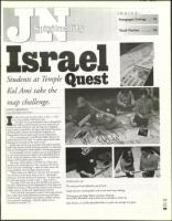
Students at Temple
Kol Ami take the
map challenge.
clues
•
DIANA LIEBERMAN
Copy Editor/Education Writer
I
is only a few steps from Jerusalem to Eilat — when
your map of Israel is 460 square feet.
On April 22, the seventh-grade class at Temple Kol
Ami religious school learned just how small and vul-
nerable the state of Israel is with the help of an inflatable
map recently purchased by the Agency for Jewish Education
of Metropolitan Detroit and the Jewish Federation of
Metropolitan Detroit's Israel and Overseas Department.
"It's an amazing tool," said Wendy Sadler, director of
school services for the AJE. "It teaches about Israel while
showing the enormity of the Arab world."
People who use the map remember what they've learned,
Sadler said, because instead of sitting passively in a classroom,
they are involving their whole bodies in the learning process.
In one popular activity, students put on special glasses
to view three-dimensional photos of unidentified sites in
Israel. Using the photos as clues, they race to match the
photos with the places they represent.
The map, which inflates to 30 feet by 15 feet, also
includes two special features. One compares the size of
Israel with that of Michigan, while the other shows the
entire Mideast, with the flags of each country.
"What makes it so effective is the fact that it's hands-
on and there are so many ways to use it," said Andee
Liberman, Kol Ami director of education. "It didn't mat-
ter what age group we used it with — they loved it."
The map, which cost more than $2,000, was used at
the Yom HaAtzmaut (Israel Independence Day) festival at
Hillel Day School of Metropolitan Detroit, and will even-
tually travel to all day and supplementary schools.
"Over 100 kids and parents stood on that map and saw
how really close those Palestinian cities are to the heart-
land of Israel," said Rabbi Scott Bolton, Hillel's commu-
nity outreach coordinator. "And the adults were as
involved as the kids." ❑
Clockwise from top:
The newly purchased inflatable map of Israel.
Temple Kol Ami seventh graders work on the Israeli map challenge.
Thirteen-year-olds Maya Weitzer and Jaime Beckwith,
both ofWest Bloomfield, study a photo clue to identifi , an Israeli city.
Max Neistein, 13, ofWest Bloomfield looks at a photo clue through 3-D glasses.
Zt‘
5/3
2002
49